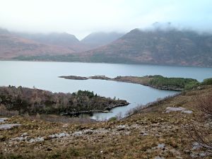
Loch Torridon
 |
|
|
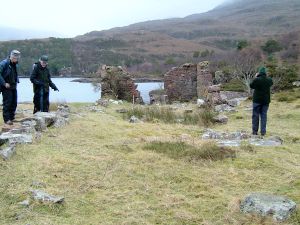
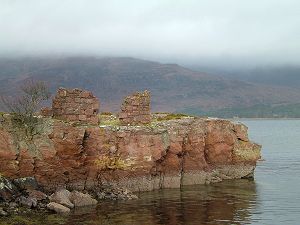
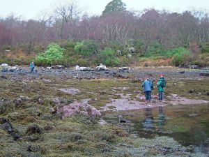
Introduction Topography Historical Background John Knox in his "Tour through the Highlands of Scotland" writes in 1787: "Here (Loch Torridon) are several anchoring places and 2 good harbours, called Great and Little Ardmore, with water from 4 to 14 fathoms, and good anchorage. They are situated contiguous to each other on the south side of the loch, near fresh water and at the bottom of sloping country, which though covered at present with heath could be cleared and drained with great facility. Thomas Newte made a tour of the West Coast in 1785, and although he never actually visited Aird Mhor, he has left a detailed description and a drawing of the curing station, almost certainly an earlier one constructed of wood. It is however possible that Newte has got it wrong, or at least inaccurate and that he has exaggerated the importance of the place. (Herring - A History of the Silver Darlings, Mike Smylie, 2004) - see Appendix Murdoch Macdonald in his book "Old Torridon" (1997), reports that by 1788, wooden warehouses, a wharf and salt storehouse had been built as well as houses for tradesmen (this information from Newte?). But the Torridon Fishery Company and its project were beset by difficulties. Mackenzie was short of funds, there was the notorious red tape involved in adhering to the Salt Laws and the Customs procedures of the day meant that all nets and boats had to be checked by the nearest Customs Officer at Isle Martin on Loch Broom. He was still employing fishermen in 1795, but by 1797 he had sold the estate to his younger brother John "excepting the fishing station established on the lands of Annat by which is understood the buildings and stores of the late company" - implying that the fishery continued to operate, but that the Company had been disbanded. The herring came and went. Some years there was plenty, an article in the "Inverness Courier" 14th Oct 1840 states: " From Loch Torridon, about 1000 crans (of herring) are taken every morning. Salt and casks are unfortunately so scarce that the vessels there purchase as many as they can get cured in a day at 3 shillings a cran and a vast quantity has been thrown into the sea. Vessels have congregated there from Ireland, the Clyde, Caithness, Stornoway and the coast near Loch Torridon. The herrings are smaller and richer in flavour than those of the Caithness coast and there are about 1000 to the barrel. It is difficult to procure labourers to cure the herring, but a number of women and boys are employed, who earn from 3 to 4 shillings a day. The "Speedy" cutter is stationed at Loch Torridon preserving order and regularity among the men and Captain Wright the commander is umpire in all disputes. Hundreds of carts are engaged in driving the herring to the east coast, and in this town (Inverness) we are almost inundated with herrings, hawked through the town at very low prices" The Curing House was still active at the end of the 19th century and probably fell into disuse in the early 20th century. ("Old Torridon", 1997) |
Gazetteer of Sites
Aird Mhoir peninsula
AM1. Boundary wall
NGR - NG 86260 54490(west end) SMR or NMRS No. -
NG 86450 54440(east end)
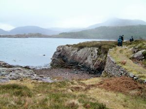
Situated in the SW of the Aird Mhor peninsula, this wall appears to separate the peninsula from the land to the south across a narrower "neck" of land. The wall is approximately 200m long, obscured by vegetation/bracken for the most part and may be a continuation of AM12 situated to the east.
AM2. ?Cleared beach - Port an t-Saoir
NGR - NG 86070 54880 SMR or NMRS No. -
Situated at the foot of a steep slope this small NW facing bay is quite exposed. It is difficult to discern whether or not this beach has been cleared of larger stones. However there appears to be a stone setting in its west corner, this could be the edge of a constructed path giving access to the beach
| AM3. ?Cleared beach and path |
|
|
|  Building AM4 from north |
|
|
|
|
|
|
|
|
 |  |
|
|  |
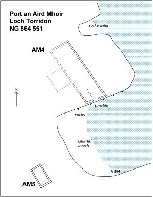
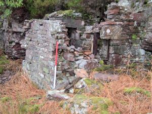
| Situated on the NE side of the Aird Mhor peninsula, at the head of a sheltered E facing bay, is Ob na Glaic Ruaidh (OS 1:10,000 map), This structure is about 5m above HWM. A platform/?jetty (AM 7) to the east may be associated, as may a wall/?fish trap in the bay to the east. The structure is at the foot of a steep south facing slope. There is an area of bracken covered, ?improved land to the west in a small east facing valley.
The aperture, which has a large lintel stone of 1.3m width, opens into a small chamber which is at least 1m in depth and 0.45m in height. |
|
|  |
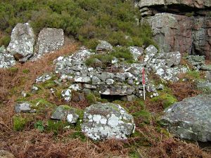
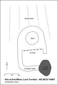
Comment - This structure is a bit of a mystery! It has been previously recorded and interpreted as a corn-drying kiln. Certainly there is a small area of ?improved land to the west, but very little other cultivatable land within the vicinity. It may be a "regional variation" of a CDK, but the aperture is more like that of a lime kiln. However it does not appear to be a lime kiln either, the shallow bowl is not appropriate for this.
Considering its situation, close to the shore at the head of a small inlet and its possible association with several features close by - ?jetty (7), wall/?fish trap (8) and building (9), also, possibly more importantly, considering its proximity to the fish Curing House (AM 4 - 150m to the NE), and the paucity of salt in the heyday of the herring fisheries, perhaps the most likely interpretation for this feature is a small Salt Pan. This structure could post date the repeal of the Salt Laws in 1825.
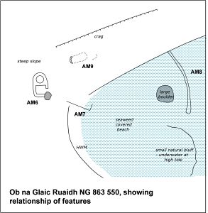
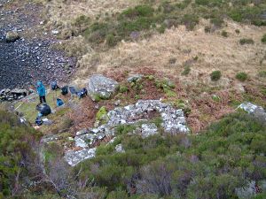
AM7 Platform/?Jetty - Ob na Glaic Ruaidh
NGR - NG 86345 54980 SMR or NMRS No.
Situated on the HWM, at the head of a sheltered E facing bay, Ob na Glaic Ruaidh (OS 1:10,000 map), The kiln (AM 6), 5m to the west may be associated, as may a wall/?fish trap (AM 8) in the bay to the east.
This roughly rectangular sloping platform, facing east, is comprised of angular stones. It is on a NW-SE alignment and measures 8.1m in length. It has a face of between 0.4m and 0.6m height on its SW side but merges with the slope to the NE. There is a "return" of 2.3m at the east end.
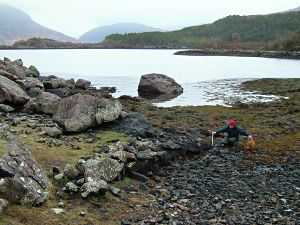
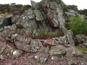
AM8 - Wall/?fish trap - Ob na Glaic Ruaidh
NGR - NG 86371 54979 (north end) SMR or NMRS No.
Situated in a sheltered E facing bay, Ob na Glaic Ruaidh (OS 1:10,000 map). Most of the time the feature is below water and only exposed at very low tide.
It comprises of a circa.20m length of wall, curving from NW to SE. There is a gap of 3m at the south end of the wall before a small natural escarpment, much of which lies underwater. The wall has a thickness of 0.8m (although wider at south end) and a max height of 1m. It is made up of large angular boulders now barnacle encrusted Wall (under water) from NW Wall (under water) from NW
and covered in seaweed.
Comment - This feature seems unlike other fish traps in that it is only exposed at very low tides. The pool which it "contains" may have been scooped out. It is possible that the feature is associated with the kiln (AM6) and the platform (AM7) - if AM6 is a salt pan then this wall could have contained the pool from where water was collected!
| AM9 Building - Ob na Glaic Ruaidh | 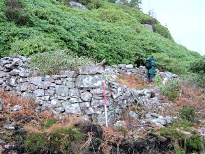 |
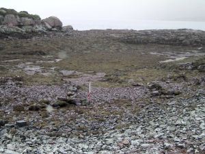
| AM10 Cleared beach - Ob Gorm Mor |
|
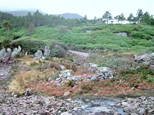
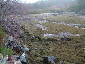
| AM11 Wreck - Ob Gorm Mor |
| AM12 - Boundary wall - Ob na Caillich |
|
 |  |
|
| |
Dubh-Aird peninsula
AM13 - Buildings - Lub Dubh Aird
NGR - NG 87146 55036 NMRS No. - Under NG85SE 21
At the west end of the bay, Lub Dubh Aird, 50m from the shoreline and at the foot of a NE facing slope.
Thesubstantial remains of a rectangular building on a NW-SE alignment with two annexes/?byres one either end of the main building. The SE annexe has had its corner cut by the new road. The annexe to the NW is rapidly becoming overgrown with rhododendrons.
The main building has upstanding walls to 1 - 1.2m height and the NW corner s rounded Main building from east
AM14 - Building - Lub Dubh Aird
NGR - NG 87151 55097 SMR or NMRS No. - Mentioned under NG85SE 21
At the west end of the bay, Lub Dubh Aird and 5m from the shoreline. A rectangular building with rounded corners on a N-S alignment. Internal dimensions 6m x 2m
A new road has been constructed close by and an area has been cleared of vegetation, possibly for a new house.
AM15 - Pen - Dubh Aird
NGR - NG 87215 55097 SMR or NMRS No.
On the east most headland of the Dubh Aird peninsula, close to the shoreline. This rectangular pen is on a NE-SW alignment. It has squared corners and internal dimensions of 7m x 4m. The low tumbled walls are 0.8m in thickness. Heather covered in the main and threatened by rhododendrons.
AM16 - Building - Dubh Aird /Sron Ghlas
NGR - NG 87155 55255 SMR or NMRS No.
On the northeast shore of the Dubh Aird peninsula a rocky outcrop is connected to the main shore by a stony beach. This building is situated at the south end of the beach and is tucked under a crag using the crag as its rear wall.
The substantial remains of this small well constructed building rise to a height of 1.6m. It appears rectangular from the outside, but internal the dimensions are 3m square. It has a doorway in the east wall and the rusting iron frame of a small
window is still in-situ in the west wall. Building AM16 from NW
AM17 - Structure/Shelter - Dubh Aird /Camas a'Bhodaich
NGR - NG 86929 55214 SMR or NMRS No.
In the NW corner of the Dubh-aird peninsula, at the head of a NE facing bay, Camas a Bhodaich. The remains of this roughly rectangular shelter are on the shoreline. Dimensions are 3.5m x 1.5m. Natural bedrock forms the rear wall and a stone setting forms the east wall.
AM18 - Cleared beach - Dubh Aird/Eilean Cnapach
NGR - NG 86861 55256 SMR or NMRS No.
Situated in the NW corner of the Dubh Aird peninsula, at the head of a N facing bay on the east side of a small island, Eilean Cnapach. This small cleared beach is NW facing.