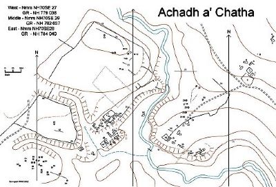
Achadh a' Chatha - (East) GR - NH 784 040
Nmrs - NH70SE 28
| Back to top | Visited Sunday 14th July 2002. Weather bright but overcast, warm and with a light breeze. The settlement is situated at a height of 370m on a SW facing slope, (400m NE of (middle) Achadh a' Chatha - NH70SE 29). It comprises of 6 buildings and 2 enclosures. An area of improved land lies at the same height to the east of this settlement. A "farmstead" of 3 unroofed buildings and an enclosure appear on the 1st edition OS map of 1872. 1 - Structure GR - NH 78419 03995. Photo 1/14 from NE
Rectangular building on a NE/SW axis - measures internally 9m x 3.5m. The remains of the stone walls have a spread of 1m and are 0.3 - 0.4m in height. Could be an entrance at N corner of SE wall, where there is also a possible annexe, 2m x 1.5m. A ?working area lies to the SE, and enclosure 2 lies 3m to NW. 2 - Enclosure GR - NH 78413 04005. Photo 1/15 from N
Roughly 13m square with very rounded corners The substantial surrounding earth and stone embankment is 0.6 - 0.7m in height (but 0.8 - 0.9m in the northern corner) and has a 1.5m spread. The SW wall is revetted out. Grassy interior is extremely lush. 3 - Structure GR - NH 78413 04029. Photo 1/18 from S, and photo 1/19 from NE
Rectangular structure on a NE/SW axis measures internally 7m x 2.5m. Two compartments, possibly 3, N is 2.5m long and S is 3.5 m, much tumble to inside. Remains of the stone walls spread to 1m and are 0.5m high. Extension of NE wall to south for 6m is 0.2m in height. Possible entrance in SE wall of south compartment 4 - Structure GR - NH 78399 04034. Photo 1/17 from SE
On a WNW/ESE axis, measures internally 8m x 2.5m. Extensive remains of the stone walls have a spread to 1.5m, particularly on the north side, and rise generally to 0.5m. Two entrances in south wall. Possible evidence of an internal wall. Generally heather covered. 5 - Structure GR - NH 78384 04017. Photo 1/16 from NE.
Rectangular structure on a NE/SW axis, much of this is completely covered with heather. Internally 8m x 2m. Southern part of the walls are very evident, rise to 0.2 - 0.3m and have a spread of 0.8m. No evidence of an entrance or of internal walls. 6 - Enclosure GR - NH 78406 03983.
Sub-rectangular, 30m x 22m, slopes gently to SW, bounded by the track on the SW where it has a retaining embankment. Embankments are incomplete. Bracken covered in south. 7 - Clearance cairn GR - NH 78443 04067. Photo 1/20 from W
Low cairn, 2.5 x 2 x 0.3m in height. 8 - Structure GR - NH 78481 04118. Photo 1/22 from SE
Rectangular building on a NW/SE axis, lies 100m to NE of main group of buildings. Measures internally 9m x 3m. Plentiful stone footings rise to 0.3 - 0.4 with spread of generally 0.7-0.8m but 1m in places. Two entrances in SW wall. Possible "annexe", 3m x 2m, on SW side - rough stone footings are barely discernible. 9 - Structure GR - NH 78487 04127. Photo 1/21 from the southwest
An oval structure on a NE/SW axis, this measures 7m x 2m internally and could be an animal pen. The low turf and stone banks are 0.3m in height and have a spread of 0.8m, they have rounded corners and are not as evident in the north. A stone alignment curves round at the NE making a possible entrance. 10 - not allocated
Achadh a' Chatha - (Middle) GR - NH 782 037
Nmrs No - NH70SE 29
| Back to top | Visited Sunday 14th July 2002. Weather bright but overcast, warm and with a light breeze. The settlement is situated at a height of 350m on a SW facing "spur" on the east bank of the Raitts Burn. It comprises of 6 buildings, 2 enclosures and a platform. An area of improved land lies to the NE of the settlement, this has a surrounding earth and stone bank. A "township" of 4 unroofed buildings and an enclosure appears on the 1st edition OS map of 1872. 11 - Linear feature/Laide GR at northwest end NH 78081 03831. Photo 1/7 east part of laide from west
The line of a ditch at an altitude of 332m can be followed for a considerable distance, although at one point at its west end it has been eroded by the burn. For the most part it is evident as a terrace, but between GR NH 78247 03694 and NH 78338 03747 it is quite substantial, being 1.5m wide and with an embankment/depth of 1m. In some parts the feature has been overwhelmed by bog. On the 1st edition OS map it is continuous towards Balavil House and at some places there has been a modern clay pipeline laid within it. It is speculated that this may be part of an early hydro scheme for Balavil House. 12 - Structure GR - NH 78267 03726. Photo 2/2 from west and Photo 2/3 middle compartments from WSW
Rectangular curving building on a NE/SW axis. It is 28m long and has 4 compartments. The westmost compartment measures internally 7m x 2.5m, the remains of the stone walls are 0.3m in height. The middle two compartments are more obvious, the west of these is 5m long and may have a door in south wall, the east is 9m x 3m. The stone wall footings of this central part are generally 0.4m and have a spread of 0.8m. A less obvious addition can be made out to the east, 4m x 2.5m, the walls are quite wasted and bracken covered - it may be a byre. 13 - Feature/?Structure GR - NH 78254 03714.
Adjacent and to the south of structure 12, a low trailing stone wall runs parallel to and 7m distant from structure 12. At its west end it curves northwards and is recessed into the slope, with a stone facing enclosing an area 4m x 3m. 14 - Feature/?Corn-drying kiln GR - NH 78248 03717. Photo 1/36 from NNE
Adjacent and at the west end of 12 and on the edge of a steep south facing slope. Two depressions on a N/S axis - south one is open to SW and there is evidence of a stone facing at the back, north one is 1.2m diameter and also has evidence of a stone edge which may be the bowl, both are 0.4-0.5m deep. 15 - Structure GR - NH 78229 03717. Photo 1/35 from ESE
Rectangular structure on an E/W axis, situated on the edge of a steep south facing slope. Internal measurement is 12m x 2.5m. The substantial remains of stone walls are 0.6m in width and 0.5m in height (but in west 1m and north 0.8m). The building is open at its E end, where there is an extension of the north wall, 3m in length. Two compartments, east is 5m long and west is 7m long. There could be an entrance, 0.6m wide, in the south wall of the west compartment. 16 - Structure GR - NH 78194 03744. Photo 1/34 from E
Rectangular structure of 3 (possibly 4) compartments on a NW/SE axis. Middle compartment has internal dimensions of 8m x 3m with much tumble in its north part. Remains of stone walls are quite substantial, 0.6m in height (at north end 1m) and spread to 1m. Entrance halfway along east wall. An "addition"/?byre at the south end, 3m square, with walls 0.5m high is open at its south end. At the north end, barely discernible in the bracken, there is a low earth bank forming a further compartment, 4m x 3m. It is open to the west. 17 - Structure GR - NH 78165 03755. Photo 1/33 from NW
Rectangular structure on a NW/SE axis, internal measurements 8m x 2.5m. Substantial ruined stone walls with 1m -1.5m spread and 0.6-0.8m height, much tumble. Open to the south, east wall extends an additional distance of 4m. 18 - Structure GR - NH 78151 03769. Photo 1/31, E. compartment from NW. Photo 1/32, W compartments from N
Rectangular building of 3 compartments on a NE/SW axis. Eastern two compartments are more substantial, middle one is 5m x 2.5m and east one 3.5m x 2.5m internally, both have entrances 0.6m wide in the south wall. The ruined stone walls spread to 1m and rise to 0.6-0.7m(0.8 in places). West compartment is 5m x 3m internally, and walls although very evident are less substantial, south wall being almost non-existent and west wall 0.4m high. 19 - Enclosure GR - NH 78144 03782. Photo 1/29, SW retaining wall from W. Photo 1/30 NW and NE walls from E
Measures internally 13m E-W, and 15m N-S. Substantial enclosing stone and turf walls with a spread of 1-1.5m and a height of 0.4-0.5m in the north and east. In the southwest the wall drops away and is revetted to a height of 1m -1.2m on the outside, the southeast edge too is revetted, to a height of 0.6-1m. The boundary wall 31 is a continuation NE of the SE wall of this enclosure. 20 - ?Platform GR - NH 78149 03804. Photo 1/27 from SSE
Rectangular terraced ?platform on a NW/SE axis, may be the base for a building. Revetted slope on southwest, 18m in length and 0.7m in height with a corner at its SE end. 21 - Structure GR - NH 78181 03785. Photo 1/28 from south
Substantial rectangular building on a NE/SW axis. Internal measurement 11m x 3m. Substantial remains of the stone walls have 1m spread and are 0.5m in height, but 1m at north end. Entrance in east end of south wall and possibly the middle where there are the stone footings of a small porch. May be an internal wall dividing off westmost 2.5m. 22 - Enclosure GR - NH 78210 03842. Photo 1/26 from NE
Abutting and on the south side of the boundary wall 31. Earth banks, with some stones, have a spread of 1-1.5m and height of 0.4m generally, are wasted in parts and enclose a rectangular internal area of 12m x 6m. Boundary wall is 1m in height at this point 23 - Clearance cairn GR - NH 78220 03855.
Low cairn, 5m x 3m x 0.4m in height, attached to and on north side of boundary wall. 24 - Clearance cairn GR - NH 78200 03861. Photo 1/24 from west
4.5m in diameter x 1m height. Small stones 25 - Clearance cairn GR - NH 78206 03876.
4m diameter x 0.6 in height (but 1m height on SW side). 26 - Clearance cairn GR - NH 78216 03899.
3m diameter x 1m height. May be recent. Large stones. 27 - Clearance cairn GR - NH 78215 03912.
3m diameter x 0.6 in height 28 - Clearance cairn GR - NH 78212 03928
3m diameter x 1m height. Large boulder 29 - Clearance cairn GR - NH 78257 03982.
4m x 2m. Could be a result of recent activity, low linear lines of clearance material are to be seen to the south 30 - Clearance cairn GR - NH 78287 03927. Photo 1/23 from N
5m x 3m. Comprised of large boulders, this could have been quite recently formed. 31 - Linear Feature/Boundary wall Photo 1/25 southern part from clearance cairn 23 looking SW
Boundary wall around area of improved land. In the southern part the wall is much enhanced by clearance material. In the NE quite it has a substantial spread to 1.5m. North part has disappeared for some distance, and then is continuous to the burn but less obvious. 32 - 39 - not allocated
Achadh a' Chatha - (West) GR - NH 779 038
NMRS No - NH70SE 27
| Back to top | Visited Sunday 14th July 2002. Weather bright but overcast, warm and with a light breeze. The settlement is situated at a height of 340m on glacial terraces of relatively fertile and well-drained land. To the north and west of the settlement there are large areas of improved ground, elevated and bisected by deepcut meltwater channels. There are two groups of buildings, each situated on its own terrace. The lower settlement has 7 buildings and 1 enclosure, the buildings appear to have been robbed of smaller stones, many of the remaining stones being quite sizeable. The upper settlement appears to be the more recently occupied. It comprises of 7 buildings and 2 enclosures. The ruins of 3 buildings and an enclosure appear on the 1st edition OS map of 1862.
Photos 2/26 and 2/27 - General view of settlement from SE A constructed track leads up to the lower settlement from the SE, it continues over a small stream, where a stone setting forms a small footbridge, and up to the upper settlement. Lower settlement - Situated on a grassy terrace, some outcrops of heather. In the western section the heather had been recently burnt. Appears to have been "robbed" of smaller stones. Photo 2/15 viewed from west. 40 - Structure GR - NH 77961 03770. Photo 2/7 from SW
On a NE/SW axis, this building is situated on a raised "spur" and slopes gently to the east. Overall length is 18m. Comprised of three compartments, the east and middle are more intact than the west. Remnants of the walls of the eastmost two compartments contain some sizeable stones (0.5m), they are generally 0.6 - 0.7m in width and 0.2 - 0.3m in height. Middle compartment is 4m x 2.5 internally, possible door in south wall, some tumble internally. East compartment is 7m x 2.5m internally, West compartment is 4m x 2.5m, walls of this are very low, a few stones only. 41 - Structure GR - NH 77953 03776. Photo 2/6 from SW
A rectangular dished area on a NE/SW axis, measuring 7m x 2m. Grassy. Occasional stones only. 42 - Structure GR - NH 77959 03786. Photo 2/5 from west.
On a NE/SW axis, mostly heather covered. Dished area internally, measures 12m x 3m. A few large stones are all that remain of the walls, some of these are 0.5m in height, but it is difficult to make out a width to the walls. No entrance evident. 43 - Structure GR - NH 77937 03771. Photo 2/4 from southeast
NW/SE axis - measures internally 10m x 3m. The low stone footings of the walls comprise of a few large stones and are roughly 0.8m in width and 0.2 - 0.3m in height. No evidence of internal walls or of an entrance. 63 - Structure GR - NH 77945 03759
Rectangular building on a NW/SE axis with internal dimension of 10m x 2.5m. Discernable as a shallow dished area in the heather. More distinct at its north end where it is recessed into the slope and a bank rises to 0.4m and there is a couple of large boulders. 44 - Structure GR - NH 77938 03754. Photo 2/8 from south.
This rectangular depression is on a N/S axis, is 0.3-0.5m deep and is open at its south end. It is 6m x 2.5m. The three sides have earth banks with 1-1.5m spread, in the NE corner the knoll reaches a height of 1m. 45 - Structure GR - NH 77929 03754. Photo 2/9 from east.
This building is 4m square internally. It is to the south and abutting onto structure 46. Rough stone footings 0.3m in height and generally 0.8m in width but with a good bit of tumble and spread. No evidence of an entrance 46 - Structure GR - NH 77925 03759. Photo 2/10 from ENE
On a NE/SW axis, this measures internally 8m x 2.5m. Large stones form the wall footings, which are 0.5m in height and generally 0.8m in width. Open at east end of south wall, but no other evidence of an entrance. Structure 45 appears to have been a later addition to the south. 47 - Enclosure GR - NH 77922 03747. Photo 2/12 from west
Measuring 14m x 11m internally, this enclosure is surrounded by an earth and stone bank. On a gentle slope which faces SW 48 - Structure GR - NH 77889 03716. Photo 2/11 from the west
A rectangular structure on a NE/SW axis this measures 7m x 2.5m internally. The low turf and stone banks are 0.1-0.2m in height. No evidence of an entrance. Covered in burnt heather and grass 49 - Structure GR - NH 77857 03729. Photo 2/13 from NW
On a NW/SE axis, internal measurements 9m x 3m. Remains of the stone walls reach 0.4-0.5m and spread to 1m. Possible entrance in E wall but no evidence of internal walls. A wasted earthbank stretches to SW, it may be the remains of an associated enclosure. 50 - Feature GR - NH 78071 03857. Photo 1/8 from east
An amorphous feature, roughly "D" shaped, lies close to and on the west bank of the stream, to the east of the settlement. It has a retaining bank, between 1 and 1.5m in height forming the curved side on the east and south. Long axis, NE/SW is 10m in length, short axis 4m. It has a few randomly-sited stones and it may be possible to make out the line of a narrow channel curving its way through the feature. Interestingly, the laide to Balavil House takes off from the opposite bank of the stream at a point just downstream of this feature. Upper settlement - Situated on a SE facing grassy terrace, just 30m to the north of the lower group of buildings. Photo 2/14 from SSW
Spring at GR NH 7786003794. Some stones probably placed strategically. Photo 2/16 from southeast. 51 - Linear feature Earth and stone embankment which bounds the large area of improved land (centred on GR - NH 77921 04227) above and to the north of settlement. It is not continuous - see plan, and has various "spurs" indicating that it has been much altered. It is quite wasted particularly in the NE. 52 - Feature/?Pen GR - NH 77979 03839
A depressed sub-rectangular area immediately to the east and in the corner of the boundary wall 51. Measures internally roughly 20m x 3m. Divided into 2 compartments by an earth and stone bank, 0.3m high, which continues west as feature 53. South compartment is 11m long and north is 9m tapering at its north end. Bounded on its east side by an earthbank, which in its southern 3m becomes a stone wall. The whole feature is depressed/dished, roughly 0.3-0.4m. Overgrown with bracken. It may be a former building which has been adapted and reused, (there are other amorphous linear features in the area) or a pen. 53 - Linear feature GR - NH 77965 03835
Remnants of a length of ?wall 0.8m in width and 0.2-0.3m in height, continues east as bisecting wall in feature 52, appears to predate stone wall 51 which it crosses. May be part of a building or enclosure.
A curving curb edge is situated to the SE where the terrace falls away. It may be a previous boundary. 54 - Enclosure GR - NH 77933 03844.
Large enclosure on a NE/SW axis, measures 30m x 16m. Substantial walls rise generally to 0.5m but 1m in many places and have a spread of 2m in places, much of this is probably clearance material. 2 small mounds, 3m in diameter and 0.2m in height lie in the north section, the west one is dished at its centre. 55 - Structure GR - NH 779500 3839. Photo 2/23 from east
Abutting enclosure 54 and to its south this building lies on a NW/SE axis and measures 7m x 2.5m internally. The wall footings are 0.8m in width and generally 0.3m in height, although 0.5m in the SW corner. 56 - Structure GR - NH 77936 03830. Photo 2/22 from NE
Abutting and to the south of enclosure 54, this building lies on a NE/SW axis. Overall measurements are 14m x 3m. There are 3 compartments, each measuring 3m by 2m internally. Stone footings of the walls are 0.2-0.3m high, grass covered. 57 - Structure GR - NH 77946 03826. Photo 2/24 from NE
On a NE/SW axis, this structure appears to be the one most recently occupied in that it has the most substantial walls of the whole settlement, they are reasonably well constructed and preserved. Building measures 10m x 3m internally and has no internal walls. The external walls rise to 0.6m height and 0.8m width but with tumble to inside making a 1-1.5m spread. The walls have dressed stone to the outside and very square corners. There is an entrance, 0.6m wide, in the east end of the south wall.
To the east of this building on the edge of the south facing slope there is a depression 2m in diameter and a further hollow to the south in which there is a evidence of a stone edge. This is very similar to Feature 14 and may have been a corn-drying kiln. 58 - Structure GR - NH 77927 03825. Photo 2/21 from WNW
On a NW/SE axis and measures 9m x 2.5m internally. Ruined stone walls are 0.4 - 0.5m in height and 0.6m in width, but with a spread to 1m. There is an entrance in the centre of the west wall and an internal wall dividing off the northern 2.5m. 59 - Enclosure GR - NH 77916 03828.
Depressed rectangular area, adjacent and to west of the large enclosure 54. Recessed into slope to north and with an earthbank as its west boundary. Measures 14m x 9m. 60 - Structure GR - NH 77911 03813. Photo 2/20 from north.
On a NE/SW axis, this building has several compartments and has overall dimensions of 13m x 3m. Middle compartment is 6m x 2m. Small compartment at west end is 1.5m. Walls to 0.5-0.6m in height generally and width of 0.8-1m. On the east end is a small addition 3m by 2m internally, it has an entrance in the south wall, clearance material appears to have been dumped in it. To the rear of this compartment there is a depression which is recessed into the slope and "faced" with 3 larger stones. 61 - Structure GR - NH 77901 03801. Photo 2/19 from NW
On a NE/SW axis and situated in an elevated position the ground dropping away to the west and south. Measures internally 10m by 3m. Quite substantial stone wall footings are generally 0.6-0.7m, but 1m in height in places and 0.8m in width. They appear to be "battered" in places. There may be an entrance in the south wall of the east compartment and a possible partition dividing off the westmost 2m. 62 - Corn Drying Kiln and Barn GR - NH 77890 03805. Photo 2/17 from east and Photo 2/18 "close-up" of kiln from east
On a NW/SE axis and a quite steep southeast facing "spur", the bowl to the north lying very much above the barn in the southern part of the building. The bowl is 2m in diameter and 1m in depth, it is fairly well intact although it does have some tumble internally. The barn is 4m x 2.5m internally and has substantial surrounding ruined walls 1m in width and 0.3m in height. There is an arc of stones in the NE corner of the barn and an entrance in the south end of the east wall 64 - 69 not allocated Improved land to north and west
Three areas of improved land lie above the settlement to the north and west. They are elevated and are separated from each other by deep meltwater channels. All gently slope to the southeast. Two are bounded or part bounded by enclosing earth and stone banks, which inevitably are made up of clearance material. The third has a good number of clearance cairns. It may be that some of the cairns and the linear clearance is as a result of more recent activity. North area is part-bounded by linear Feature 51. In the SE part and much covered with bracken there are several truncated linear banks, some appear to delineate areas of level ground, others run NW-SE on the steeper slopes and are perhaps attempts at offering some kind of protection from the prevailing wind. There is a recently constructed fenced enclosure. Also within the area are:
70 - Clearance cairn at NH 77972 04018
71 - Clearance cairn at NH 77998 04054
72 - Clearance cairn at NH 78024 04070
73 - Clearance cairn at NH 78003 04071
74 - Clearance cairn at NH 77987 04090
75 - Clearance cairn at NH 77919 03138
76 - Clearance cairn at NH 77953 04073
77 - Linear earth and stone bank centred on NH 77998 04035
78 - Linear earth and stone bank from NH 77983 04097 to NH 77884 04163
79 - not allocated Middle area is completely bounded by:
80 - Linear Feature - an earth and stone bank. Photo 2/25 south part of wall from east. Within it are:
81 - Clearance cairn at NH 77744 03818
82 - Linear earth and stone bank, north end at NH 77747 03796 West area has no enclosing boundary. Within the area are:
83 - Clearance cairn at NH 77627 03670 is 3x2 0.3m in height
84 - Clearance cairn at NH 77647 03687 is 4x2 0.5m in height
85 - Clearance cairn at NH 77674 03693 is 4m diameter x 0.9m in height
86 - Clearance cairn at NH 77693 03701
87 - Clearance cairn at NH 77685 03689 is 2x1x0.3m in height
88 - Clearance cairn at NH 77678 03680
89 - Clearance cairn at NH 77709 03687
90 - Clearance cairn at NH 77694 03673
91 - Clearance cairn at NH 77672 03667
92 - Clearance cairn at NH 77702 03654
93 - Clearance cairn at NH 77740 03664
94 - Clearance cairn at NH 77724 03647
95 - Linear earth and stone bank roughly stretching between 94 and 96
96 - Clearance cairn at NH 77795 03618
Raitts Burn - a NOSAS Project
| | Site name and SMR or NMRS No.
Raitts Burn (?Achavourich) | Location
Alvie Parish, Highland Region | | NGR
NH 77615 04969 | Site type/class
Structure | | Situation and surroundings
SE facing and with a panoramic view of the Northern Cairngorm mountains this structure is situated in an exposed location at an altitude of 390m.
Related Record - Achadh a' Chatha | | Description
Substantial remains of a substantial rectangular building on a NNE-SSW axis. Internal dimensions roughly 28m x 3mWalls - constructed of large dressed stones, courses 0.8m in width. Remains of NW wall rise to 1m, are turfed up at the rear and have much tumble to the inside. Remains of SE wall are roughly 0.5m high and have evidence of 3 entrances (see sketch). Evidence of two internal dividing walls at the west end, in the form of partial low stone footings. | On 1st Edition OS map or others - 1st Edition OS | | Recorder, Date and Weather conditions - M.Marshall - 27.01.03. Weather - cold and windy | |
Comments, associated features, possible interpretation: Possible Victorian shooting lodge?Bill Ramsey remembers this as being called Achavourich. Fraser Mackintosh (1848) in his lists of people evicted in 1806 has Alexander Gordon of Achavourich of Raitts, but I could find no evidence of other habitations in the immediate vicinity - MM
|
Place Names around Raitts , Badenoch
Some notes and observations from Bill Ramsay now resident in Kyle, who was born and brought up in the area note 1(courtesy of Ann Wakeling) [click links for notes] 1. Raitts (NH 791027) (now Balavil House) - "Rath" = fortified house - Rait on Gordon and Bleau maps of 1640 and Raiths on Roy map of 1750
2. Lynchat - Loin note 2 a' chait note 3 = homestead of the sheepcote - cata is obsolete gaelic word for sheepcote, however old residents called it Baile a' chait
3. Chapel park (NH 787019) - Pairc an t'-seipeil, chapel dedicated to St. Maluag, also the site of an old Inn:
4. Tullysow - the innkeeper was called John MacPherson, died 1805, and buried in St Columbas churchyard, Kingussie. Sign on the front door read "Tadhailibh an so" = visit here or call in, hence Tully or Tilly
5. Tillysoul House (NH 785019) - ?demolished after last war
6. Kerrow Dow note 4 (NH 779023) - Ceathramh Dubh = black or dark quarter - (?Mid Rait on Gordon map of 1640 - WR)
7. Baldow note 4 (NH 777023) - Baile dubh = dark township - (?Mid Rait on Gordon map of 1640 - WR)
8. Upper Raitts (NH 774023) - (?West or Wester Rait on Gordon & Bleau maps of 1640 - WR)
9. Creag Righ Tharailt or Harailt (NH 791 062) - site of grave of the leader of a group of Scandinavians defeated in in a fight near Loch Insh
10. Achaha (NH 779038) - Achaidh a' Chadha note 3 = ?Field of struggle or fight, or Achadh a' Chatha note 3 = Field of sheep or sheepcote
11. Acharumach (NH 782038) - Achadh a' runnaich = Field of the marshy place
12. Achavourich - Achadh a' bhurich (NH 776049) = place of the roaring of the stags
13. Lynvoan (NH 781020) - Loinn note 2 a' mhonadh = place of the moorland. Also Tiravoan - Tir a'mhonadh = land of the moor
14. Tigh a' Chuirn - Tigh na cairne or Tynacairn= house of/beside a cairn
15. Tigh a' Chaim ( NH 773 018) - Tynacaime- house of or near the crooked burn (Allt Cealagh)
16. Laggan (NH 768 017)
17. Tigh na Camahe - reputed to be the house of the witch of Laggan
18. Strathinlea (?NH 840 040) - a mystery! NOTES
1 Bill Ramsay's forebears on his mothers side were McEdwards, MacBeans and Macphersons. Angus MacEdward was a cattle drover and lived at Kerrow Meadhonach, the existing Kerrow Farm (NH 766015). He was married to the daughter of Edward Shaw Macintosh (Borlum). Shaws widow was forced to sell Raitts to James Macpherson in 1788.
2 In Kingussie and Badenoch, Loinn or Lainn means a dwelling or homestead, a place or enclosed land for agricultural purposes, something like "baile"
3 Gaelic dictionary definitions:
"cadha" or "catha" - a pass, a narrow, an entry (also "a steep place" in Badenoch and Strathspey)
"cath" - a battle, a fight, struggle
"cat" - a cat; heap of potatoes or corn
"c(h)ait", "cat or cata" (in Badenoch and Strathspey) - a sheepcot or pen
"caith" or "cath" - winnow corn
4 It is speculate that these were names used after the first clearance. The earlier maps of Bleau and Gordon 1640-54 refer to West Rait, Mid Rait and Rait. The two names, Kerrowdubh and Baldow, do not appear prior to 1803. On Fraser Mackintoshes "list" the 1801,1802 and 1803 evictions have no mention of the two names, whilst the 1806 list has no mention of Midtown of Raitts. Could Mid Rait have been changed to Baldow and/or Kerrowdow? On close inspection the surnames of the people evicted are roughly the same ie. Macdonald, Robertson and Cattanach. After all who would refer to their homes in such derogatory terms as Baldow and Kerrowdow! A similar exercise can be done with Wester Raitts and Upper Raitts where the surnames Macpherson, Macbean and Gordon re-occur. M. Marshall 12.01.03 | | |