| Description
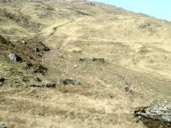
Comprises 3 ruined buildings and 2 enclosures. Surrounded by the remains of an iron "deer-proof" fence. Generally rough heathland, with several small patches of improved land. Covers an area of roughly 1 hectare.
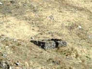
Upper building
Rectangular, E-W alignment, internal measurements 4.5m x 3m
- walls, well constructed and consistently to a height of 1.5m and width of 0.7m, squarish corners - entrance in S wall 1m wide, small window in west wall, 0.4 square metres. Middle/Main building
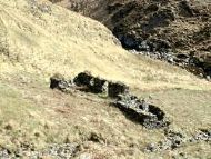
Rectangular, E-W alignment, 2 compartments. Small stream to west.
East compartment, internal measurement 8m x 3m, walls variable in height from 1.5m to 0.2 (tumbled in places) width consistently of 0.6m, corners squarish, entrance in south wall with lintel at 1.5m, also window.
West compartment, internally 3m x 2.5m walls generally to 1.5m height, (tumbled in SW corner) and 0.6m width, small window, partially blocked in south wall.
A built-up terrace with a small escarpment and (in front of the entrance), a faced wall to 1m height lies in front of this building. Improved land lies down slope. Lower building
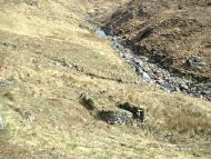
Rectangular, E-W alignment, internally 5m x 2.5m.
- walls, more roughly constructed than previous 2 buildings, generally to height of 1- 1.5m but tumbled in SE corner, 0.5m in width, battered" to some extent. Corners rounded++
- possible remains of small platform and ? Entrance at SE corner
- improved ground to SW and enclosure to NW. Small stream to east. Enclosures
- In NW - steeply sloping and SE facing, includes a shallower strip 30m x 7m next to the stream
- In east - triangular area, roughly 25m sides of easier SW facing ground. A constructed track way connects this to the main building (see plan). |